Shoreline Management Plan policy options

Shoreline Management Plans define the best approach to managing flood and erosion risk.
A Shoreline Management Plan (SMP) defines the best approach to managing coastal flood and erosion risk for a particular section of coastline. The four approaches (called ‘policy options’ in UK government guidance) are:
- Hold the line (HTL): Build or maintain artificial defences to keep the current position of the shoreline. This can involve maintaining or changing the standard of protection
- Advance the line (ATL): Build new defences on the seaward side of the original defences. This is rarely used and is limited to policy units where significant land reclamation is considered
- Managed realignment (MR): Allow the shoreline to move backwards or forwards naturally but manage the process to direct it in certain areas
- No active intervention (NAI): No planned investment in coastal defences or operations, regardless of whether or not an artificial defence has previously existed
Once the policy option has been defined, shoreline managers must find the best way to achieve it within constraints such as budget, stakeholder needs and carbon management.
"The Shoreline Management Plan sets the policy but doesn’t provide many of the details on how it can or should be delivered," says Simon Burchett, technical director (coastal) at consultancy WSP. "The policy considers environmental, engineering and economic aspects but in broad terms only. Delivering the policy is often heavily reliant on whether the economic business case can be made. You have densely populated areas where an economic case can be easier to make for 'hold the line' and other areas where ‘no active intervention’ is often the case."
What interventions can be made?

Rock armour in Felixstowe, Suffolk. By the 1980s, rock armour was one of the preferred coastal defences in the UK.
Coastal defences are intended to provide protection against damage or injury from waves and seawater. In the UK, in the Victorian era, they consisted mainly of fields of timber groynes and piers on beaches, many of which have fallen into disrepair. These were later supplemented with masonry seawalls, often with vertical faces, which were labour-intensive to build and costly and difficult to maintain safely.
From the 1950s to the 1970s, large concrete blocks were placed on beaches to dissipate wave energy. However, these have suffered from a range of problems, including voids that are not visible from the outside, and are now reaching the end of their design life.
By the 1980s, the preferred solutions were rock armour – large boulders interlocked to form rock revetments – and beach recharge, where sand and shingle has been replaced on depleted beaches. These were seen as ‘soft’ engineering solutions at the time, in contrast to the previous use of concrete, but the trend now is to work more closely with natural processes and make use of the inherent capabilities of beaches and coastal ecosystems. "Now rock armour is considered ‘hard’ engineering, and 'soft' solutions are things like vegetated beaches," Burchett says.
A systems approach to resilience
The resilience of an existing or new coastal defence solution in the face of climate change should not be assessed in isolation, but as part of a wider ‘system’ that includes not just the solution itself – a seawall, for example – but also the beach and surrounding ecosystems, such as sea grass beds, dunes and marshes.
"Engineering solutions developed in the past have shown various degrees of resilience, depending on how they have been implemented and the philosophy behind them," explains Maria di Leo, technical director for coasts and oceans at consultancy HR Wallingford. "In general, solutions allowing for system adaptation have shown a better performance."
However, even if a seawall retains its structural integrity in the face of rising sea levels and increased wave action, this does not necessarily mean the whole system is resilient. "Typically, under wave attack, the beach in front of a seawall is likely to reduce its width and draw down, because of the hydrodynamic conditions induced by the wall itself," di Leo notes.
"Under more severe wave conditions this situation can only worsen," she adds. "A system like this may not have the capacity to find a new equilibrium that is satisfactory for our needs, so beach drawdown is likely to continue, and localised scour may affect the structure’s toe, eventually undermining it. A new equilibrium is likely to be reached, but it might involve some changes to the structure itself, including a structural failure."
As a result, she says, traditional hold the line interventions that consist mainly of 'hard' structures, with limited scope for beach readjustment, offer limited resilience, whereas solutions that allow some 'buffering' have proved to be more successful.
"The more flexible the system is, the better chance it stands of being resilient over time," she says. "Flexibility increases a system’s ability to cope with changes. If you don’t have that flexibility, you will have to keep on intervening."
Managed realignment at Medmerry

Image credit: Number 10
Medmerry, which is located between Selsey and Bracklesham in the south of England, is the UK's largest managed realignment scheme on the open coast.
The project was instigated by the UK's Environment Agency and included the construction of 7km of new flood defences, up to 2km inland from the original coastline, to protect 350 homes and businesses.
Once the defences were complete, a large section of the original shingle beach was removed to allow the sea into the area in front of the new inland sea defences, creating a 250ha area where the sea could follow its natural patterns.
The sea now flows into and out of this area every tide, leaving shallow lagoons and areas of muddy ground that are now a habitat for protected wildlife.
Solutions
A systems approach involves understanding not only how the sea behaves, but also the capacity for natural features and vegetation to assist in flood prevention. "Coastal engineering solutions can leverage the wave dissipation ability of beaches and their ecosystems – like dunes, seagrass beds and kelp beds – and enhance it," Maria di Leo explains. “The best way to promote resilience is allowing for natural beach dynamism rather than trying to restrain it.
"A beach evolves and adapts continuously, but to do so it needs space: enough space for the dunes to grow and then release sediment when needed, and then grow again. But also space for intertidal and subtidal ecosystems to live and thrive, whilst contributing to wave dissipation."
Studies have shown that the ability of different types of marine vegetation to dissipate wave energy can be accurately predicted. Some key findings from studies are shown in the image below.

Similarly, sand dunes can provide defence against flooding but are rarely able to do so because they are not being recharged naturally as a result of other changes in the ‘system’, such as rock armour or revetments at their base, or nearby seawalls.
Di Leo says: "Ideally, soft interventions that enhance beach dynamism, such as dune reconstruction and beach nourishment, add to beaches’ potential to modify and adapt, and dynamically protect whatever lies behind them. From this perspective they offer a more resilient solution to the effects of climate change."
Still, she adds: "Hard structures may well still be needed, but they should be seen as a last line of defence rather than a primary protection provider."
Densely populated coastal areas where a hold the line approach has been agreed will almost inevitably require some form of 'hard' engineering intervention to prevent flooding. There is now a move to ensure these structures provide additional benefits, including public realm or ecological enhancement, such as creating rock pools within rock armour structures and texturing the surface of reefs and seawalls to provide habitat for plants and molluscs.
Portsea Island: Holding the line on England's south coast

Image credit: M J Richardson
A major flood defence scheme is under way to achieve a ‘hold the line’ strategy for the north of Portsea Island on England’s south coast.
A total of 8.4km of new defences are being constructed in five phases to protect the 1,906 residential properties and 160 commercial properties that are currently at risk of flooding. This could increase to 4,234 homes and 490 business premises if sea levels rise.
Phase 4, which is currently under construction, includes a concrete seawall with a surface texture designed to cultivate local marine life. Coastal Partners, a partnership of four local authorities that manages the local coastline, surveyed the foreshore and then designed the wall’s surface to include holes, crevices and texturing to attract different species, including crabs, limpets and seaweed.
Coastal Partners also hopes that the vegetation growing on the wall will absorb wave energy, reduce temperature fluctuations and reduce salt ingress and egress into the local ground water to create a more stable environment.
Sharing knowledge between SMP areas
The coastline of England has been divided up into Shoreline Management Plan units, or ‘cells’, based on the movement of beach material. These are intended to be relatively self-contained, with boundaries where coastal processes do not interact and where sediment doesn’t move. However, sediment transport can occur either side of these boundaries, so harmonisation of beach management plans between SMP units is essential.
“Engineering choices made upstream may influence what happens downstream,” Maria di Leo says. “For example, if a set of groynes is planned at a certain location, sediment transport reaching a beach downstream will be reduced, because groynes trap sediment. These changes need to be captured by management plans at downstream locations, otherwise the assumptions on which SMPs are developed would not stand.”
A resilient future
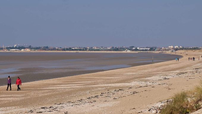
Plage d'Aytré, France. Image: Thierry Llansades
Predicted sea level rises and increased prevalence of storms will make it more difficult to protect every coastal community with a hold the line approach, and some difficult decisions will need to be made as to which communities are protected and which are not.
Shoreline Management Plans are intended to be ‘living’ documents that respond to changing circumstances and there are already examples of changes in policy where the original approach is no longer appropriate, such as at Pagham Harbour, Climping and Cuckmere Haven in the South Downs SMP area.
In some places, the most viable option may be to move a community further inland rather than trying to protect it, as has been done at Aytré on France’s west coast, where the government bought and demolished 50 beachfront homes following devastating flooding.
Sign up to receive news from ICE Knowledge direct to your inbox.